
Main image: Ashina, CC BY-SA 3.0 https://creativecommons.org/licenses/by-sa/3.0, via Wikimedia Commons
One can get to Aktau by different modes of transport: air, land, water. Depends on which city you plan to make your trip to Aktau from.
You can use railway if you are traveling from the cities of Kazakhstan. This travel option will be more economical.
You can reach Aktau by ferry only from Baku. It will take a day, but it will be more affordable than Baku-Aktau flight.
You can get to Aktau by taxi, rented car or electric bus. The bus departs from 6:00 am at hourly intervals.
Aktau International Airport hosts domestic and international flights of such airlines as Air Astana, Turkish Airlines, Atlasglobal, Aeroflot, S7 Airlines, Azerbaijan Airlines, etc. Aktau International Airport is located 25 km northwest of the city of Aktau
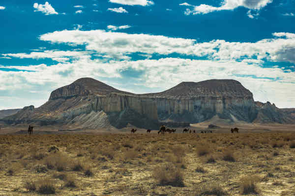
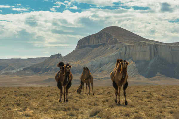
Any trip to the Mangystau region must start from the regional center, the city of Aktau. Its main attraction is the new embankment. Here, for example, an open-air amphitheater was built. Also, a staircase 102 meters long and 24 meters wide was built on the embankment, a bike path was laid, and small architectural forms of mythical characters were installed on the Mythos Square. After that, you can safely go deep into the Mangystau Peninsula! The nature here is harsh, but beautiful, most of the landscapes seem to be intended for shooting space movies with aliens and other planets.
Mangystau region landmarks
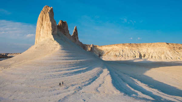
- Bozzhyra, two sharp peaks, often called Fangs, from the base of which you can admire the bizarre castle wall.
- The legendary Mount Sherkala is a snow-white fortress that changes its appearance if you go around it.
- Zhygylgan – Fallen Earth, the edge of which is almost a regular circle with a diameter of at least 10 kilometers.
- Tuzbair is a rocky area and salt marsh in the Mangistau region in the southeast of Kazakhstan, near the large Ustyurt plateau.
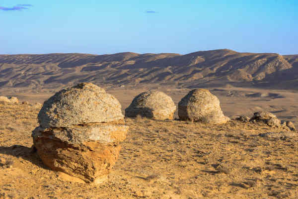
- The valley of globular nodules Torysh, striking with its unearthly appearance.
- Kapamsay chalk canyon, where one can see a real workshop in which tools of the Stone Age era were made.
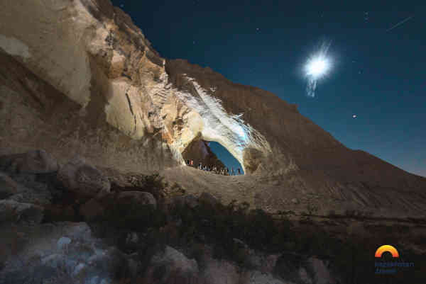
Historical and sacred places of Mangystau region include the Underground mosques Beket-ata, Shakpak-ata, Shopan-ata, Sultan-epe, etc., which are popular destinations for the domestic pilgrims even today.
The Mangyshlak Peninsula (the modern name is Mangistau) has a rich history. Archaeologists are aware of numerous Paleolithic monuments found on the coast of Sarytash Bay, on the Tyubkaragan peninsula and in the valleys of the Shakhbagat and Kumakape rivers. There are finds from the Neolithic era, for example, the Koskuduk I site on the coast of the Caspian Sea, dating from the end of the 5th – the first half of the 4th millennium BC. e. That is, people have lived here since time immemorial.
In the Middle Ages Mangyshlak became a trade field and economic relations arena between East and West. The area was mapped by Fedor Ivanovich Soimonov during the Caspian Expedition, which surveyed the Caspian Sea from 1719 to 1727.
There are several versions about the origin of the name Mangyshlak. In ancient times, “Mangyshlak” was called “Ming-kishlak” – “a thousand winter apartments”. Professor of St. Petersburg University V. V. Grigoriev “Mangyshlak” translated from Turkmen as “a thousand wanderings”. In the geographic-statistical dictionary of the Russian Empire, the word “Mangyshlak” is explained as “winter nomad camps” (from the Turkic “menk” – one of the Nogai tribes and “kishlak” – winter nomad camps). The Turkmen scientist K. Annaniyazov believes that “Mangyshlak” means a large settlement, since “man” is translated as big, “gyshlak” is a settlement.
Traditional cultural events of international and republican levels are held annually in the region: the Republican Kyuis Performers Competition named after M. Oskinbayuly, Regional Shubat Gastronomic Festival, Nauryz Amal Celebration.
- Every year since 2013 the Festival of Music and Sports “Aktau Open Fest, a large-scale event that brings together all residents and guests of the city in the open air of the Caspian coast has been held in Aktau. Performers and athletes from everywhere come to Aktau to perform at the event.
- Every year on May 1, another large-scale event is held in Aktau, the opening of the biker season. Bikers have a tradition: to come together at the Shlyapa cafe opposite the 5th microdistrict at 11.00 every year on May 1, this is the place where the motorcycle race begins, which opens the motorcycle season. Residents and guests of the city activly participate in the event.
- Caspiy Tour Fest
- Shokhr Boltekuly International Memorial Boxing Tournament
Mangystau is located in the south-west of Kazakhstan, at the junction of the only inland sea on the planet – the Caspian Sea – and a huge desert lying below the level of the World Ocean.
The region has very different climatic conditions. In Northern Mangystau, it is cold in winter due to the Ustyurt plateau, located mainly above sea level. In general, the climate is continental with cold winters and mild summers. The average temperature is -3°C in January and +26°C in July.
The average annual rainfall is 150 millimeters (5.9 inches). The climate of the Mangystau region is formed under the predominant influence of the Arctic, Iranian and Turanian air masses. In the cold period of the year, air masses dominate here, coming from the western spur of the Siberian anticyclone; in the warm period, they are replaced by overheated tropical masses from the deserts of Central Asia and Iran. Under the influence of these air masses, a sharply continental extremely arid type of climate is formed.
Mangystau Oblast is an industrial region where about 25% of Kazakhstan’s oil is produced. On the territory of the region, about 60 deposits of hydrocarbon raw materials have been explored with total recoverable reserves of oil – 702,542 thousand tons, gas – 157,730 million m³, condensate – 4.7 million tons, 27 fields are being developed. Uzen unique oil and gas field with recoverable reserves of about 500 million tons of oil, Zhetybai oil and gas condensate with reserves of about 150 million tons, Karazhanbas oil and gas fields, North Buzachi. Kalamkas with total initial reserves of over 350 million tons.
The region accounts for:
- 10.6% of the industrial production of the Republic;
- 27.7% of the republican oil production;
- 93.4% of the republican production of nitrogen fertilizers;
The region has sufficient potential for the development of enterprises in the chemical, machine-building and metal-working industries. The bowels are rich in reserves of oil, gas, phosphorite, coal, manganese, various salts, and shell rock.


