
Getting There
You can reach there are two ways to reach there, by bus or car. You can take a bus from Baku International Bus Complex, which operates daily. Once you’ve reached Ismayilli, you can take a taxi or use bus to reach Zarnava village. If you travel by car, once you arrive at Ismayilli, in order to reach Zarnava village, you need to the Muganli-Ismayilli road and drive along the asphalt road in the direction of Lahij. After a while, we leave the easy road and go down a rocky dirt road.
What to Expect
Muju village hiking route – Surrounded by scenic mountains, Muju village (Mücü) is located in the piedmont of Mount Fit (Fit dağı) at 7 km from historic Basgal town (Basqal). Muju was once settled by Mountain Jews and a Jewish cemetery in the village is a testimony to its Jewish heritage. Currently, about 15 families (not Jewish) reside in the village. The village is accessible with off-road vehicles via Basgal.The hiking trail goes through protected forests of Shahdag National Park (Şahdağ Milli Parkı), crosses over small streams and reaches a summer pasture at 2000 m above sea level. At this vantage point, there are breathtaking views of Lahij and surrounding villages, snow-capped Great Caucasus Mountains dividing Guba (Quba) and Ismayilli (İsmayıllı) districts, as well as Babadag peak (Babadağ, 3629 m). While approaching the pasture, the trail goes into a rocky landscape and gets narrower. Therefore, it is recommended that this part of the trail be carefully followed. This interesting trail is recommended for those people who like hard and long mountain hikes. Distance is 10 km, duration 5 hours,with starting point in Muju village and finishing with Lahij village.
Zarnava – Mushkamir trail – While driving to historic Lahij town (Lahıc) many people think of what is behind those steep cliffs surrounding the road. One may be surprised to learn that in fact those cliffs are not impassable and you can reach behind-the-cliffs Zarnava and Mushkamir villages on foot!Zarnava village (Zərnava) is located in the piedmont of Niyaldag mountain range (Niyaldağ) and surrounded by forests. Sitting at 1360 metres above sea level, the village is settled by tat people, an ethnic group speaking a local Iranian language.
Life in the village is traditional and villagers are engaged in animal husbandry and charcoal making. There are no paved roads leading to the village and one must cross the Girdiman stream (Girdiman) in off-road cars to reach it.
There is a famous suspension bridge for pedestrians (asma körpü) over the Girdiman stream and the proposed hiking trail starts at this point by crossing this bridge.Mushkamir village (Müşkəmir) is another settlement with a traditional lifestyle on the hiking trail after Zarnava. Sitting at 1180 metres above sea level, the village is located in the piedmont of Niyaldag mountain range and surrounded by forests.The end point of the trail is Gandov village (Gəndov) located on the main road leading from Ismayilli city (İsmayıllı) to Lahij. There are around 20 families living in this settlement.Distance is 7 km,duration 3 hours.
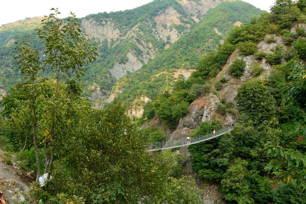
Suspension Bridge – Zarnava trail – While driving to historic Lahij town (Lahıc) many people think of what is behind those steep cliffs surrounding the road. One may be surprised to learn that in fact those cliffs are not impassable and you can reach behind-the-cliffs Zarnava and Mushkamir villages on foot! Zarnava village (Zərnava) is located in the piedmont of Niyaldag mountain range (Niyaldağ) and surrounded by forests.
Sitting at 1360 meters above sea level, the village is settled by tat people, an ethnic group speaking a local Iranian language. Life in the village is traditional and villagers are engaged in animal husbandry and charcoal making. There are no paved roads leading to the village and one must cross the Girdiman stream (Girdiman) in off-road cars to reach it. There is a famous suspension bridge for pedestrians (asma körpü) over the Girdiman stream and the proposed hiking trail starts at this point by crossing this bridge.
Darakand – Kohnadakhar trail – The end point of the proposed hiking trail is Kohnadakhar village (Köhnədaxar) which is located over Darakand village and hosts around 30 families of Tat origin. The main economic activity here is charcoal making which leaves negative impact on surrounding forests. However, some maiden forests still remain in impassable areas. The village is 5 kilometres from the main road and can be reached in off-road cars.Hiking around the surrounding mountains and through authentic Tat villages with breath-taking views of Girdiman valley and Niyaldag mountain range (Niyaldağ) is to be a very interesting and memorable experience. Those hikers who want to complete the proposed trail till Kohnadakhar village may hire local villagers’ vehicles there and return to the main road at Gandov village. For hikers who experience difficulty at steep ascends it is advised to go up to Kohnadakhar village in off-road cars and then descend the trail in opposite direction. Distance is 3.1 km,duration 2.5 hours.
Gandov – Darakand trail – On the left bank of the Girdiman stream (Girdiman) and the old road leading to Lahij town (Lahıc) in Ismayilli district (İsmayıllı) there are several smaller villages some of which are not accessible with a car. These villages are settled by Tat people, an ethnic group speaking a local Iranian language. Villagers cultivate potatoes and legumes, as well as engage in animal husbandry and charcoal making.One of these villages is Gandov (Gəndov) which is located on the road to Lahij town. There are about 20 families residing here. Gandov village is the start point of the proposed hiking trail.Next point on the hiking trail is Darakand – a small village accessible only on foot or on horse. Population varies with season – there are around 8-9 families living here in summer months and only 5 families in winter months. The word “Darakand” means “a village in a small valley or hollow” as the village is located deep in a mountain valley. A small stream nearby is draining into a bigger Girdiman stream.Distance is 5 km,duration.
Garanohur lake hiking trail – Lake Garanohur is a mountain lake located in the Ismayilli district. The lake is 12 km north-east of the city of Ismayilli at 1,533m above sea level.The lake is in the Shahdagh National Park and roads lead to it from the villages of Talistan, Diyally and Kekhna-Dakhar. The main tourist route begins in the village of Talistan. The total distance from the entrance to the Shahdag National Park to the lake is 5.5km and the trail runs all the way through wooded areas. 4km of the total distance is a steady incline while the remaining 1km is steeper. The route is marked from beginning to the end, allowing for safe walking all the way. Distance 5.5 km, duration 3 hours.


